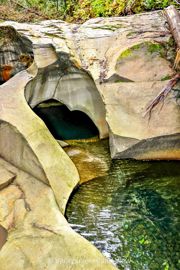
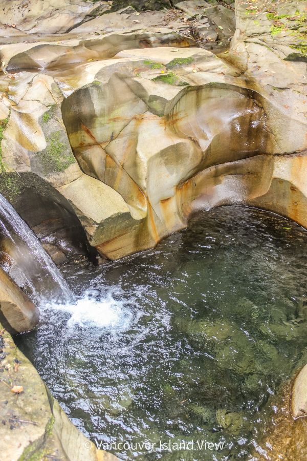
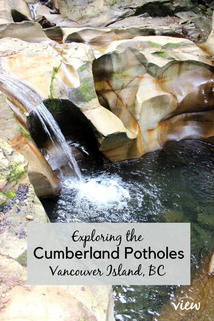
Tucked into the forest near Cumberland, the Potholes are a dramatic stretch of Perseverance Creek where rushing water has carved smooth, swirling rock formations. Best admired in the rainy season, these natural sculptures come alive when the creek is full and flowing.
Quick Guide to Cumberland Potholes
- Unique Gem: Explore this unique topography, attracting those who appreciate distinctive landscapes.
- Trail Details: Embark on a 4 km round trip to the Potholes, accessible via the Cumberland Forest. This moderate hike promises an enjoyable journey for beginners and seasoned hikers alike.
- Trail Name: Also known as China Bowls or Perseverance Potholes, the hike along Perseverance Creek promises a perfect adventure.
- Best-Kept Secret: Cumberland is often regarded as one of Vancouver Island's best-kept secrets, and it is worth exploring.
This article may contain affiliate links, which means that if you happen to make a purchase, I may receive a small commission at no extra cost to you. Please read our privacy policy for more information.
What to Expect
The Cumberland Potholes are situated in a relatively small area, but the surrounding trails are extensive. The dramatic landscape and topography of the potholes make the hike so worthwhile.
While you are there, make sure to take note of your surroundings. Notice the smoothness of the rock pools carved out by the flowing water, their unique shapes, deep colours, and dark and intriguing crevices. And let's not forget the peaceful beauty of it all!
When to Go
This gem, tucked into Cumberland's forests, should not be missed. However, it's best to visit during the rainy season. During the dry summer months, Perseverance Creek slows to a trickle, leaving the rock basins quiet and still—far from their dramatic rainy-season display.
So, despite what other online publications say, this is NOT a swimming destination, nor will you see the deep pools you've most likely seen online if you go during the dry season. The photos shown in this article were all taken in March.
Summer is also when the area becomes a critical migration corridor for Western Toads, with thousands moving between the creek and the surrounding forest. High foot traffic during this time can harm these sensitive amphibians and other wildlife. In fact, as of July 31, 2025, there is a voluntary closure in the area for this very reason.
For both the best experience and the health of the ecosystem, plan your visit for the rainy season (late fall through spring), when heavy rains bring the Potholes to life and the local wildlife is less vulnerable.
Getting to the Cumberland Potholes
- Take the Cumberland exit and start heading towards Comox Lake.
- There is a large gravel parking lot at the corner of Dunsmuir Avenue (also Royston Road) and Sutton Road (for the Cumberland Recreation Centre). You can park here and walk the few hundred metres to the trailhead; OR, park just after the 90° corner (where Sutton Road becomes Comox Lake Road) on the side of the road (bringing you closest to the trailhead).
The Hike
The hike to the Cumberland Potholes is approximately 2 km (one way). If you wish to continue, many more hiking and biking trails surround the area.
- Walk through the yellow gate and enter a large system of biking and hiking trails.
- At the sign, turn right and head up the hill.
- You will pass through a forested area and a clear-cut area (approximately 1 km from the sign at the bottom).
- When you arrive at another forested area (after the clear-cut), stay right (there will be quite a few trails veering off to your left).
- When you reach the bridge, take the trail on either side and head downstream.
- You have arrived!
Wheelchair / Stroller Accessible?
While most of the trail is uphill, it is a well-maintained, very wide path that makes it stroller-friendly. However, please note that walking around the Cumberland Potholes requires sure footing. The rocks are very slippery, and there are a few really deep pools (during the rainy season). Please watch your children at all times.
Dog-Friendly?
The trail leading up to the Cumberland Potholes is dog-friendly. A sign at the trailhead states that dogs must be on a leash. As mentioned above, the area is extremely slippery once at the Potholes. And if you are continuing downstream, you'll need to scamper and jump across rocks, some of which are pretty steep.
Hidden Gems in the Area
If you like this hike, we have several hidden gems in the Comox Valley. The majority of our hidden gems require a membership to Vancouver Island View, which gives you access to an Exclusive Membership Area. Once you join, you will have full guides to the following off-the-beaten-track locations in the Comox Valley:
- A Hidden High-Elevation Lake and Waterfall
- Hidden Mine Ruins
- Secret Potholes (that are even bigger and better than these ones)
- An Abandoned Mill Site
- Plus many more
While you are in Cumberland
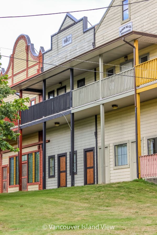
It would be a shame to be in Cumberland and not wander around the village to take in the local sights.
Founded in 1888, early settlement in Cumberland was due to the coal mines. Miners and their families came from across North America, Europe, China and Japan to reap the benefits of the regular shipments of high-grade steam coal. The area became home to the fifth-largest Chinese settlement in BC.
Not only did the coal mine bring a profit to both the town and its workers, but it also brought great heartache. Two major mine explosions happened in the early 1920s. In August 1922, the first killed 13 men, while the second, less than six months later (Feb. 1923), killed 33 men.
At the Japanese and Chinese Cemeteries, you can find the tombstones of many victims clustered together.
While in the area, delve into Cumberland's history, dating back to its coal mining roots, at the Cumberland Museum and Archives. This enriching experience offers insights into the town's fascinating past.
Today, Cumberland is a vibrant community built on outdoor recreation. It is known as a legendary mountain biking area. Many parks and an abundance of trails surround the village.
The Village of Cumberland
Despite its small size, you’ll find an eclectic mix of boutique shops, heritage buildings, and a thriving café and restaurant scene that rivals much larger communities.
From cozy coffee spots to creative eateries and pubs, the dining options here are both plentiful and highly regarded, making Cumberland a rewarding stop whether you’re here for a meal, a wander, or a base for nearby adventures.
Here are a few of my favourite not-to-miss spots.
Riders Pizza – A local favourite known for its hand-tossed pizzas piled high with fresh ingredients and inventive flavour combinations. The laid-back, welcoming atmosphere makes it the perfect place to refuel after a day of exploring.
Cumberland Brewing Company – This small-batch brewery is big on flavour, offering a rotating selection of craft beers brewed right in the heart of the village. Pair a pint with their tasty tapas-style bites and soak up the friendly, community vibe.
Cumberland Village Bakery – A historic gem that’s been serving locals and visitors for decades. Famous for its mouthwatering doughnuts and other baked treats, it’s a must-visit for anyone with a sweet tooth—or an appreciation for old-fashioned charm.
Why Visit the Area
The Cumberland Potholes are one of Vancouver Island’s most fascinating natural features, best admired when the rainy season swells Perseverance Creek into a rushing, sculpted wonder. In summer, the low water flow and sensitive Western Toad migration make it a time to give this special spot a rest—ensuring it remains healthy and vibrant for future visits.
Fortunately, any trip to Cumberland offers plenty to enjoy, from its rich history and charming main street to its excellent dining scene, making it a rewarding destination in any season.
If you want to keep this post for future reference, don't forget to save it to Pinterest!
Subscribe Today!
Like what you are reading? Subscribe to our newsletter to learn more about the best ways to explore Vancouver Island, and you'll also receive this free adventure guide.


From the Village of Cumberland’ FaceBook page (31/07/25)
“Please avoid the area to help protect animal habitat and water quality, including Western Toads.
The Perseverance Creek potholes have become a popular destination for visitors drawn to images of the creek during high flows.
However, high recreational use is resulting in trampling of riparian area vegetation and is negatively impacting water quality in the creek and animals in the area.
The area is currently part of the migration corridor for juvenile Western toads, a species of conservation concern. The area is also home to endangered red legged frogs, wandering salamanders and provides critical flow for downstream juvenile salmonids during dry summer months.
Public cooperation will contribute to the protection of this special place in the Cumberland Community Forest Park.”
Thank you for this! I just came across this very thing this morning and haven’t had a chance to post anything.
We went there this past weekend, what a treat! There wasn’t any flowing water, but still beautiful and easy to climb around. Thanks for your instructions on how to find! One of the highlights of our trip.
That’s wonderful to hear, Jess! I’m so glad you enjoyed the area and that my directions helped you find it.
Thank you so much for the detailed and accurate directions on where to park and how to get there!! We are from Vancouver and went there for a visit. We were having trouble finding the place thanks to Google map and found your site which saved us from wandering around in circles. 1000x thanks! Will mention your site when writing my Google review. It was absolutely worth going!! The china bowls are so cool.
I’m so glad you found this article helpful! And thank you for letting me know!!
We arrived to a closed road and had to change the plans in the last minute – went to Mt. Washington.
Well, that’s interesting? Which road was closed?
Hey everybody, please note that if you are visiting the ‘Cumberland potholes’ during the summer months they are definitely not ok for swimming. The creek is fish bearing and the water is very low during the summer. Anyone entering the water would potentially be damaging a very sensitive water system. Enjoy the view!
I am dyslexic ! – Did you mean Comox LAKE road ?! thanks, I love your fa
bulous site!!!
Ah shoot, yes, I meant Comox Lake Road. Thank you for catching that! It’s been fixed.
Is it child friendly? Not like trent
Yes, I would say Cumberland Potholes is more child-friendly than Trent River. There are no roped trails to contend with like there is at Trent River. The trail to the Cumberland Potholes is a nice easy trail. The only part you will need to be concerned with are the potholes themselves, as they can be very slippery. However, with a bit of extra caution, totally doable. We typically always hike with our kids, and they really enjoyed this one. (They would have been approximately 9 and 7 at the time we did this hike).
In your ‘Getting There’ to the Cumberland potholes you mention “At the corner of Royston Road and Sutton Road, ” . Should it not be Dunsmuir and Sutton?
Royston turns into Dunsmuir, so you are quite right. By the time you get to Sutton, you are indeed on Dunsmuir. Thank you for the catch! I’ll update the post.
Your site is beautiful. Under the title ‘While you are in the area’ you mention shipments of ‘high grade steam’. How can steam be shipped?
Ahhh! That would be a typo! There isn’t supposed to be an “and” in there. Thank you so much for noticing. It is all fixed up now.