North Vancouver Island Things to Do
Are you looking for a great Vancouver Island road trip idea? Explore the less travelled roads of Vancouver Island North to experience scenic and culturally rich towns.
Known locally as the Island Highway, Highway 19 is the main thoroughfare connecting the communities of Vancouver Island North with Nanaimo and many towns in between.
The route from Nanaimo to Port Hardy (the furthest north you can drive on the Island) is approximately 390 km.
So, if you drive right through, you can technically do the trip in one day. However, it is always recommended to take it slow to enjoy all the sights.
This article contains some affiliate links, which means if you happen to make a purchase after clicking on a link, I may receive a small commission. I appreciate your support.
Nanaimo to Campbell River or Victoria to Campbell River
We already have several articles that showcase the various activities to see and do in and around Nanaimo, the Parksville area, and the Comox Valley.
To avoid repeating ourselves too much, this article showcases the must-see highlights of a Vancouver Island road trip from Campbell River to Port Hardy.
If you need some guidance on the top things to see before reaching Campbell River, here are some suggestions:
- 5-Day Vancouver Island Itinerary (covers Victoria to the West Coast)
- Victoria to Nanaimo
- Oceanside Route Road Trip (Parkville to Campbell River)

Is North Vancouver Island Worth Visiting?
When tourists plan an upcoming trip to Vancouver Island, we often get this question. We always answer, “Yes! North Vancouver Island is always worth visiting!”.
But there's a catch: You can't visit this area without having access to a vehicle. So, a vehicle, whether your own or a rental car, is a must! Once you have secured one, your options are limitless.
The island's north end is the least developed area, so wildlife is abundant.
On any given trip, expect to see black bears, deer, elk, and an overabundance of eagles. This is why ensuring you know how to handle yourself around wild animals is vitally important. When on the water, you'll most likely see seals, sea lions, otters, and whales. So binoculars and a zoom lens, if you are a photographer, are essential things to bring.
The lush and rugged rainforest provides many wonderful opportunities to hike and camp and the villages dotted throughout the area offer amazing cultural experiences.
So, let's dive right in!
Campbell River Area
The Campbell River area, known as the “Salmon Capital of the World,” is a vibrant coastal community nestled between the rugged wilderness of northern Vancouver Island and the tranquil waters of Discovery Passage. With its stunning ocean views, nearby islands, and towering mountains, Campbell River is an outdoor enthusiast’s paradise.
Visitors can enjoy world-class fishing, wildlife viewing, including bears and whales, and endless hiking and biking trails through lush forests. Rich in both Indigenous and settler history, this area blends natural beauty with cultural depth, offering a diverse range of activities and experiences.
Campbell River Highlights
When visiting Campbell River, there are several must-see highlights that showcase the area's natural beauty and cultural richness:
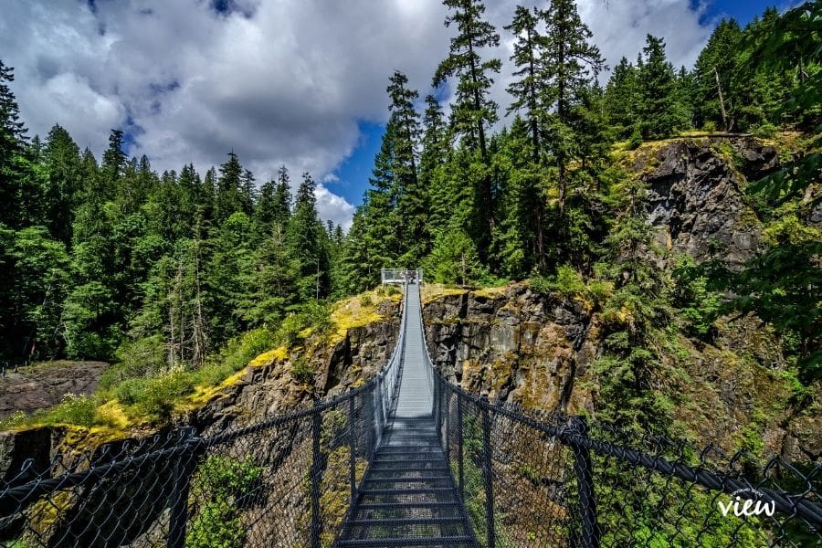
1. Elk Falls Provincial Park
This stunning park is home to the impressive Elk Falls, where a suspension bridge offers breathtaking views of the waterfall plunging into a canyon. The park also has well-maintained hiking trails that take you through lush forests. Its extensive 6 km trail system is home to the only significant stand of old-growth Douglas fir north of MacMillan Provincial Park (Cathedral Grove).
2. Discovery Pier
A unique spot for a leisurely stroll, Discovery Pier offers panoramic ocean views, with opportunities to spot marine wildlife like seals and eagles. It's also a popular fishing spot, and the pier’s concessions serve delicious fish and chips.
3. The Museum at Campbell River
This museum provides a fascinating look into the area's history, including its Indigenous heritage, the fishing and logging industries, and early European settlement. Don’t miss the exhibits on local wildlife and First Nations art.
4. Whale Watching and Wildlife Tours
Campbell River is a prime location for wildlife tours, including whale watching. Spot orcas, humpback whales, dolphins, and sea lions in their natural habitat as you explore the stunning waters of Discovery Passage and Johnstone Strait.
5. Quinsam River Hatchery
This hatchery focuses on salmon conservation and is a great stop for learning about local wildlife. Visitors can witness the incredible salmon run up close during the spawning season (typically in the fall).
6. Quadra Island
A short ferry ride from Campbell River, Quadra Island, is perfect for day trips. It offers serene hiking trails, artisan shops, and picturesque beaches, making it an ideal escape into nature.
These highlights provide a glimpse into Campbell River’s blend of outdoor adventure, wildlife, and rich cultural experiences—perfect for any visitor!
Recommended Campbell River Hotels
For visitors seeking exceptional accommodations in Campbell River, the newest gem is Naturally Pacific Resort, a luxurious retreat that combines modern elegance with the area’s natural beauty. This resort offers world-class dining and upscale amenities, making it the perfect choice for relaxing in style. Other popular options include the historic Painter’s Lodge, known for its rustic charm and fishing adventures, and the centrally located Anchor Inn & Suites, offering easy access to local attractions and comfortable, family-friendly lodging.

Strathcona Provincial Park
Strathcona Provincial Park, Vancouver Island’s oldest and largest park, is a breathtaking wilderness haven that offers an unparalleled escape into nature. Covering over 250,000 hectares of rugged mountains, pristine lakes, and dense forests, the park is a paradise for outdoor enthusiasts and adventure seekers.
Home to some of the island’s most iconic landmarks, including the towering peaks of the Golden Hinde and Mount Albert Edward, as well as the crystal-clear waters of Buttle Lake, Strathcona Park offers endless opportunities for hiking, camping, wildlife viewing, and backcountry exploration.
Whether you’re after challenging alpine treks, serene paddling experiences, or simply a peaceful nature retreat, Strathcona Park delivers a raw and untamed beauty that’s hard to match. It's a destination for those wanting to truly unwind and escape it all. With no cell coverage or WiFi and pit toilets as the only amenities, you are quite literally leaving the rest of the world behind.

North Island Route
The stretch of Highway that extends past Campbell River is named the North Island Route.
This paved, double-lane highway section is particularly scenic, offering views of jagged mountain peaks, expansive forests and frequent wildlife sightings. The highway is well-maintained and motorhome-friendly.
Little Huson Caves
Located within the Regional District of Mount Waddington, Little Huson Caves offers a small yet spectacular taste of the island's karst topography.
The park is centred around Atluck Creek Canyon, an area of breathtaking natural beauty. Visitors can view and explore several amazing karst features and 15 caves.
One of the best features of this park is that you don't have to go underground (unless you want to) to experience and view these natural phenomena.

Telegraph Cove
This postcard-ready boardwalk community is nestled at the northern end of Johnstone Strait.
From its preserved historic multicoloured buildings on stilts to the picture-perfect ocean views, Telegraph Cove remains an iconic eco-tourism destination on Vancouver Island.
During the summer, this snug little community bustles with travellers eager to view whales, catch fish, camp and kayak along the sheltered waters and secluded inlets.
With its many eco-tours, it's a village that offers a great selection of truly magnificent adventures and activities you can partake in.
A must-see and do is a guided trip to the Broughton Archipelago.

Port McNeill
Port McNeill is a proud forestry community. So it makes sense that while there, you can view the world's largest burls (there are two!).
The world’s second-largest burl (formerly the largest) was cut from the base of a 351-year-old Sitka Spruce tree in 1976. This burl weighs an estimated 22 tons and measures 13.7 meters in circumference.
At the time of its discovery, it was the largest burl. A 2005 discovery later displaced it from its position.
It's located in a not-so-blatant area in the town centre and is protected by trees, bushes, and a structure (in an abandoned parking lot).
Please note the signpost near the burl hasn’t been updated and still says “the world’s largest burl.”
The largest of the two burls was carved off a tall Sitka Spruce tree near Holberg in 2005. It is 6 meters tall and 6 meters in diameter and weighs an estimated 30 tons. This one is just outside town, off SW Main Road (off Hwy 19 N).
Port McNeill is also a gateway to two fascinating northern islands (keep reading below).

Malcolm Island
Malcolm Island is where Orcas rub against the smooth pebbled beach, and humans go to create lasting memories.
While relatively small in size (24 km long and 3 km wide at its narrowest point) and with a population of only 684 (2016), Malcolm Island offers much to its visitors.
You will find breathtaking scenery, outstanding outdoor experiences, ample wildlife viewing opportunities, and a fascinating history.
A 25-minute ferry ride from the Port McNeill harbour links to Malcolm Island. The Ferry service runs between Port McNeill, Sointula, and Alert Bay seven days a week.
The schedule is somewhat convoluted, so check the BC Ferries website for updates before you go.

Alert Bay (Cormorant Island)
Explore this working coastal town proudly celebrating its First Nations and Pioneer heritage. It has a steep history worth learning about.
From the world-renowned U’mista Cultural Centre to the world's tallest totem pole, Alert Bay is known internationally as a centre for First Nations Culture.
The pristine waterways surrounding Cormorant Island are some of the best places to find resident Orcas. The area is also known for Humpback, Minke, and Transient killer whales.
And if you ask me, it's a must-see stop on any Vancouver Island North road trip!
Cormorant Island, home of Alert Bay, is linked by a 35-minute ferry ride from Port McNeill, which follows the same schedule mentioned above.

What is the most northern point of Vancouver Island?
Port Hardy marks the end of Highway 19 and is the northernmost town on Vancouver Island. It is a gateway to many outdoor activities, including fishing, world-class scuba diving, caving, kayaking, boating, hiking, and nature viewing.
Things to See and Do in Port Hardy
Top things to do in Port Hardy
- Stroll the miles of sand or build sandcastles on Storey's Beach.
- Walk along the beautiful boardwalk trail.
- Explore the tidal pools in Hardy Bay at low tide.
- Walk the seawall of Hardy Bay and read the interpretive signage along the way.
- If you have a boat, head to God's Pocket.
- Take a guided fish hatchery tour and view world-class exhibits and interactive displays.
- Dive at Bear Cove – a haven for marine life!
- Go on a guided fishing charter and try catching the ‘big one.'
- Indulge in candied smoked salmon made by famous locals, ‘Hardy Buoys Smoked Fish.'
- Head to the Port Hardy Museum for a history lesson.
- Hike to a plane crash.
- Storm watch at the Blow Hole at Thomas Point.
- Drive to Coal Harbour and/or Cape Scott

San Josef Bay and Cape Scott
Due to the many stunning images floating around social media, this incredible area of Vancouver Island North is becoming increasingly popular.
Cape Scott Provincial Park is a walk-in-only park. The one parking lot is only accessible via a very long drive down a rough logging road.
However, if you are up for the adventure, you will have access to pristine rainforests, majestic beaches and unspoiled nature.
Please note: If you have a rental car, and depending on their policies, driving this road may not be permitted. Please check in with the rental company before you go!
Need a Place to Stay while touring Vancouver Island North?
As mentioned above, Port Hardy is the gateway to many great activities and adventures for the northernmost areas of Vancouver Island. It's also the perfect location to lay your head. My top recommendation is the First Nations-owned Kwa'Lilas Hotel. It's located right in the heart of town.
If that's not available, here are some other Port Hardy hotels.
If you'd rather rent a place of your own there are also several Vacation rentals in the Vancouver Island North.
Vancouver Island North Road Trip Summary
By now, you’ve likely realized how much adventure awaits on a Vancouver Island North road trip. From the rugged coastline and untamed wilderness to the rich cultural heritage and diverse wildlife, this region offers experiences that are as unique as they are unforgettable.
Whether you’re exploring the ancient rainforests, searching for whales along the shoreline, or discovering hidden gems in remote communities, Vancouver Island North promises a road trip like no other.
So, which stops are calling your name? What adventure are you most excited to embark on? Let us know your favourite sights, activities, or hidden gems in the comments below. We’d love to hear about your journey!
Save this article on Pinterest for future use:

Other Vancouver Island Road Trip Ideas
Subscribe Today!
Like what you are reading? Subscribe to our newsletter to learn more about the best ways to explore Vancouver Island, and you'll also receive this free adventure guide.
Best Travel Resources
🚗 Car Rentals: Find the best price on car rentals with Rentalcars.com (a Bookings.com company).
🏨Hotel Bookings: Bookings.com is my favourite resource for booking accommodations. Their cancellation policy is unbeatable.
🏡 Vacation Rentals: Vrbo is my top choice for all your vacation rental needs! Find the best vacation rentals throughout Vancouver Island and beyond.
✈️Browse Cheap Flights: Flight Hub is proudly Canadian and they offer deals and prices to worldwide destinations.
🌴 Full-service vacations: Redtag.ca is a fantastic vacation booking site for Canadians that offers Flights, Hotels, Car Rentals, Cruises, and All-Inclusive Vacations with great deals.
🐋Guided Tours: Viator is the most straightforward website for booking tours, experiences, and activities all over Vancouver Island and elsewhere.
🌳Provincial Park Reservations: BC Parks to book Provincial Park campgrounds and backcountry areas around Vancouver Island.
🚍 RV Rentals: If you want to rent a camper, motorhome, campervan, or travel trailer, look no further than RVezy. Input your destination in the location search bar to find the perfect RV for your camping needs.
⛴️ Ferry Guide: Use this guide to get to Vancouver Island.
🚌 Bus Guide: Use this bus guide for all the bus services across Vancouver Island.
🥾Best Trails App: AllTrails – This app/website provides tools for great trail adventures. It offers offline maps, alerts for when you take a wrong turn, the ability to create a list of favourite local trails, map details, and the ability to find trails anywhere. It's honestly my most used app.
🚙Off-Road Adventures: The Vancouver Island Backroad Mapbook is essential for exploring off-the-beaten-path locations. It's my #1 resource for discovering hidden gems.


Hi We’re coming to Port Alice at the end of September/beginning of October and would be really grateful if you have any useful nuggets of information that we could have. We’ve never been this far north on the island before and we’re really looking forward to seeing a different Vancouver Island. As I say any tips on what to do would be gratefully received. Many thanks :}
I am an Islander and still have much to explore. I also love !! the cover of Vancouver Is. North road trip . Can your tell me who the artist/photographer is. Thank you!
The North Island is a spectacular place to explore. As for the “cover”, I’m not sure which one you mean…but the large photo (at the bottom) was taken by me while at Little Huson Caves. The featured image you see when on the main page/category for the North Island, is a stock photo from Getty images – as I didn’t have the right photo for the job.
c
Thank you for writing the articles that you do! I have been a subscriber from the beginning & look forward to every new destination & highlight you present. With this latest feature being the North Island, I could hardly contain my excitement! Sadly though as a resident of Port McNeill, I was truly disappointed in how our beautiful little town was represented. Yes we are a logging community, but we are also so much more! For starters from Port McNeill you can go whale watching, diving, kayaking, fishing, boating, hiking as well as helicopter tours. A sea to sky experience is a reality here. We are also the gateway to the Broughton Archipelago, a boaters mecca, where people come from all over to enjoy the solitude & wildlife viewing opportunities our area provides! I truly hope you return to our area at some point and give us the opportunity we deserve!
Hi Cindy, thank you so much for being such a devoted reader of Vancouver Island View. I am so sorry you feel I misrepresented Port McNeill. I have to admit I haven’t spent much time in your beautiful area. From my point of view, Port Hardy and Port McNeill offer very similar experiences and excursions (but please correct me if I am wrong). So with hopes of not being too repetitive in the article, I focussed on the uniqueness of Port McNeill (that which Port Hardy doesn’t offer). I take your feedback to heart and only hope I get another chance to tour your area!